I’ll be the first to admit it, I’m no weatherman and I personally feel like it’s one of the hardest things to predict when it comes to snowboard mountaineering. I often get asked tho, where do you look for weather, when do you start looking and what are some good tools. It’s simple when the weather calls for a blue bird day, but what if it says partly cloudy, a chance of snow, etc. How do you really know when you’re weather pocket is going to be, what elevations will the mountain be socked in and so forth? Well… I’m still learning that too but here is what I’ve learned so far for figuring out weather in the PNW!
When do you start looking at the weather and what is my process?
Ten days out from an objective is generally when I start looking at the weather. Since I’m a weekend warrior, I can’t always just head out when the weather is perfect. So a lot of the time I have to make a decision if the weather is “good enough” for a trip up a mountain. I find that weather 10 days out is still a long shot and if it looks like a storm front is starting or leaving around that date, then it could happen a day before or after too.
I usually hop on OpenSnow and check out the resorts in that area for their 6-10 day forecast. I’ve created a dashboard on OpenSnow to see all of the resorts in the PNW region and this gives me a better idea of where the storm is coming in the heaviest and where the freeze levels are.
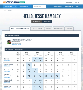
OpenSnow.com
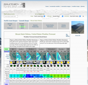
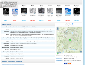
Mountain-Forecast.com
For NOAA, I use it in three ways. One is to look at the broad PNW weather. The second is to use their pinpoint forecasting by searching for something like “Mt. St. Helens noaa” and then clicking on the map to get the elevation and aspect I want. From there, you can get a 7 day forecast but it’s really general. To really dive into the weather, you need to go to the menu in the bottom and use the “Hourly Weather Forecast” and the “Forecast Discussion” and I’ll discuss those below. The third way I use NOAA is their cloud level predictions. This is really useful for trying to figure out if the mountain will be socked in or not. Notice that the forecasts are in UTC time, so you’ll need to translate them into your region.
NOAA Pinpoint Forecasting
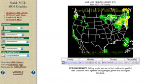
MET MOS Ceiling Height
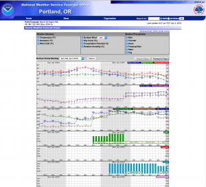
One to three days out is when I really start to use the “Hourly Weather Forecast” and the “Forecast Discussion” from NOAA. Using the “Hourly Weather Forecast”, let’s you pull up a graph with a handful of very useful weather forecasts like wind, temps, precipitation potential, sky cover, etc. I find that these will continue to update and narrow down up until the night before. So it’s highly useful in figuring out good weather pockets. Remember when using this tool, it’s only for the elevation you picked when using the pinpoint map, so you can pick another zone if you’d like to check another elevation.
One thing I learned last year while flying in a Cessna is that pilots are often looking at the weather the same way that mountaineers do. Single prop and smaller planes are usually flying around the same elevation that mountaineers are climbing at. So I find that you can get some useful information from the “Forecast Discussion” section of NOAA and reading the aviation forecast. It’s a little hard to decipher sometimes, but do some googling and you’ll easily figure it out and understand what they are talking about with cloud types and visibility. I find that looking up the weather to the closest area to where you’re climbing on Wunderground works too. You’ll see on the right side of the forecast will have some aviation codes and will provide you cloud levels and what elevations they are at. This information, combined with the cloud level predictions should give you a better idea of if the mountain is going to be socked in during your climb and what time.
I keep checking these forecasts until I’m leaving the door. Just remember tho, weather on a mountain can change at any time, so always be prepared.
NOAA Hourly Weather Forecast
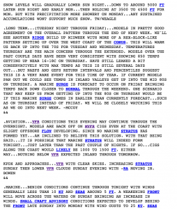
NOAA Forecast Discussion
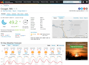
Wunderground.com
What tools or apps do you use?
As mentioned above, I often use these tools for checking the weather forecasts:
- OpenSnow
- Mountain-Forecast
- NOAA
- NOAA – Pinpoint Forecasting – google something like “Mt. St. Helens Noaa”
- NOAA – Hourly Weather Forecast – get to from pinpoint forecasting
- NOAA – Forecast Discussion – get to from pinpoint forecsting
- NOAA – Regional Weather
- NOOA – MET MOS CEILING HEIGHT
- Wunderground
- NOAA World Radar – IOS App – useful for seeing real time clouds anywhere
I hope you find this information useful and I plan to keep writing more posts as I discover new tools to help me with weather forecasting.